1451 Peters Mountain Road Dauphin PA 17018 phone: 717-921-8100 fax: 717-921-8276

Watershed Associations
Water Resources Main Page
Stream Health Report
Water Resource Interactive Map

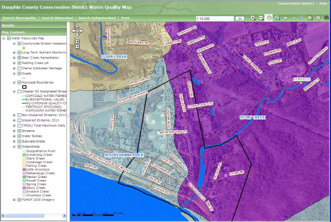
The Dauphin County Water Resources Interactive Map has recently been created.  The map allows users to search a municipality or watershed, as well as manually zooming to a location of interest.  Stream classification such as designated use, impaired/non-impaired status, and TMDL information is provided.  Please refer to the Help link in the upper right corner of the map for information on how to use the map tools. 
The Dauphin County Conservation District, along with Dauphin County GIS updates the map and its database to improve spatial accuracy and attribute information.  The information contained in this map should not be relied upon by anyone as a determination of water quality or stream designation.  No warranties, expressed or implied, are provided for the positional or thematic accuracy of the data herein, its use, or its interpretation.  Although updates are provided, the information may not reflect the data currently on file in the Dauphin County Water Quality Database.

Note: The GIS web site requires Microsoft Internet Explorer 4.0 or higher or Netscape Navigator 6.0 or higher.

If you are using a dial up connection please be aware that you may experience a slower response time when using this application.

Water Resources Interactive Map

The Pennsylvania Department of Environmental Protection supplies current shapefile layers for Impaired Streams, Non-Impaired Streams, TMDL, and Chapter 93 Stream Designated Uses on the PASDA website.

Dauphin County Water Resource Interactive Map